 .home page .back Tutorials. GA Planes
The terms 'Altimeter settings' point to the fact that the altimeter gauge, in a plane, has to be set to a reference value, as it works like a barometer does, being part of the Pitot system which is taking the measurements of the static and dynamic atmospheric pressure around the plane, on the ground or in flight. That way, as far as the flights performed at a low, or mean altitude are concerned, they will have a safe altitude relative to the relief below and, at the same time, all the planes flying in a same airspace will have a same reference for their altitude relative to each other. The other use of the altimeter settings is for the airspace located above 18,000 ft (in the USA) as the planes -mostly airliners- flying there will have the same altitude's settings with which they will determine their flight level! To get a simple view of such settings -and provided that you'll check what our tutorial describes with data taken from more advanced site- we'll assume that the use of the altimeter settings, in FS2002, may ground upon the following
The atmospheric pressure, generally speaking, may be considered the 'weight' of the atmosphere in a given location, and as measured with a barometer. That weight is function of the number of the particles of the air. The atmospheric pressure is measured, in the Anglo-Saxon world, through the use of the 'inHg' (inch of mercury) unit as in the European countries, the unit is the millibar (mb) or the hectopascal (hPa) with the millibar and the hectopascal equivalent. A standard description of the atmosphere has been deviced, providing with the data used in the aeronautics. The atmospheric pressure at the sea level, with a temperature of 59°F (15°.C), has a value of 29.92 inHg (or 1013.2 hPa, or mb). Such a standard value also determines the parameters of the variation of the atmospheric pressure function of the altitude. Considering that the average decrease of temperature through the altitude establishes itself at 2°C for each 1,000 ft, the atmospheric endures a decrease of 1 inHg each 1,000 ft (or 110 hPa each 3,300 ft). The atmospheric pressure thus is varying function of the altitude. The more you climb in altitude, the less the atmospheric pressure (due to that the particles of the air are in a lesser number). On another hand, the atmospheric pressure also is varying according to the weather. A warm and rainy weather front will yield a low atmospheric pressure as a cold front a high atmospheric pressure. The temperature too is affecting the atmospheric pressure, with the pressure of warm air larger than the one of the cold air
Now, let's be back to the altimeter settings. That will be done relative to a known value which may be qualified official for the aeronautical uses and, practically, that is done through a knob located on the altimeter gauge. The knob allows to set a value of reference to the altimeter, which in turn, is giving us the plane's altitude. In FS, two main types of reference atmospheric pressure, or altimeter settings, are of use. A one called 'current reported altimeter setting' (in the US), or 'QNH' (in countries like France, for example), which is used for the flight at low or mean altitude. And the one, qualified 'Standard Atmosphere' which is of use for the high altitude flights only. The QNH is a barometric measure of the atmospheric pressure for a given aeronautical area, such like, in the USA, for the given area of a airpace control region:
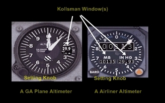 | setting the altimeter |
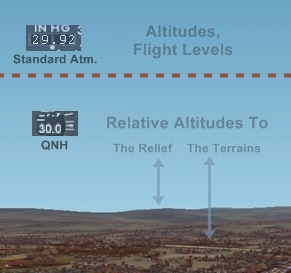 | the current reported altimeter setting or QNH atmospheric pressure value mostly relates to the altitudes relatively to the relief and terrains |
The more advanced, your version of the FS franchise, the more the barometric settings are available like, with the possibility, for example, of downloading real weather data. The atmospheric pressure, in FS2002 mostly is related to two settings. The weather menu. The altimeter's setting. A form of unaccuracy in FS2002 might let assume that the value to be defined inside the weather menu be the 'usual', weather atmospheric pressure as given by your daily weathe report or a barometer. The value that you'll set in that menu however is the current reported altimeter setting or QNH one! As the current reported altimeter setting or QNH atmospheric pressure value is the weather value of a area, as corrected to the atmospheric pressure at the sea level, a simple and pertaining way to procede with that setting, in the weather menu, is to determine the atmospheric pressure we want to use in relation with the weather type we are applying -let's say, 28.94 inHg, like an example- and then to correct that to the sea level atmosphere! With our example, should we assume that the weather atmospheric pressure for the area be 28.94 inHg and that the airport is lying at a altitude of 1,650 ft, let's turn 28.94 into 30.59. Why that? Just because the usual weather value for our weather system is a value measured function too of the altitude of the terrain. As the mean atmospheric pressure is considered decreasing -thus increasing, reciprocally, of 1 inHg each 1,000 ft, the pressure we are defining would, so, be more important at the sea level than at the altitude of the airport where we are. Once that corrected value set in the altimeter gauge's Kollsman window, we'll consider it like the current reported altimeter setting or QNH value! As the altimeter's Kollman knob, in FS, have a range of between 27.99 inHg (948 mb) and 32.01 inHg (1084), that is limiting, of course, the QNH values to that range, as far as the sea level is concerned. At a terrain located near the seashore, in Florida, in the US, for example, no lower atmospheric weather pressure than 27.99, or a higher than 32.01 inHg will be allowed. Such current reported altimeter setting or QNH values, as allowed in FS, however are a further hindrance as far as the airports with a important altitude are concerned. A airport like at Denver, with a altitude of 5,431 ft can not get a realistic current reported altimeter setting or QNH due to that, or just, maybe, whether one takes into accound the impact of the air temperature unto the air density at that altitude, with the atmospheric pressure of the warm air larger than that of the cold air. Thus, for the current reported altimeter setting or QNH atmospheric values which cannot fit between the 27.99-32.01 inHg range, we'll have to simulate, not to use the real, weather atmospheric pressure for the area that is. Or we'll have to apply a systematical correction to the altitude as displayed by the altimeter, with is not handy in terms of pilotage
Like a conclusion, one can point to another setting for the altimeter. It's termed the 'QFE' atmospheric value. The QFE value is just the non-corrected to the sea level atmospheric pressure value, weather pressure value for a given airport. It's now rarely used by pilots, and when it is used, it's mostly for the airport traffic pattern operations only. As, when on the ground, setting the altimeter to the QFE value, the latter will dislay a value of zero for the altitude. In that way, the pilot is able to straightly read the altitude of the plane relatively to the ground, during the traffic pattern operations, or some airport ones, strictly. That may be simplier. For a airport, for example, which has a altitue of 950 ft, to set the altimeter with the QFE, will have, with a traffic pattern performed at 1,000 ft, the altimeter displaying 1,000 ft, instead of 1,950, like with the current reported altimeter setting or QNH set
Website Manager: G. Guichard, site Lessons In Microsoft Flight Simulator / Leçons de vol pour les Flight Simulator de Microsoft, http://flightlessons.6te.net.htm. Page Editor: G. Guichard. last edited: 5/27/2013. contact us at ggwebsites@outlook.com