 .home page .back Tutorials. IFR
Due to the development of the satellite navigation GPS systems worldwide, a transition is now occurring in the aviation world -as the move started in the USA- from flights based upon ground radionav aids to flights upon GPS systems. That evolution is also true as far as approaches are concerned. For both occurences, the FMCs, those onboard computers, are featured with databases encompassing such routes and approaches. Those new ways to flight IFR are moreover part, in the USA, of the 'Wide Area Augmentation System' (WAAS) concept which is aiming, through a network of ground stations, to improve the accuracy of the GPS system in regard to aviation both for lateral navigation (heading) and vertical (altitude)
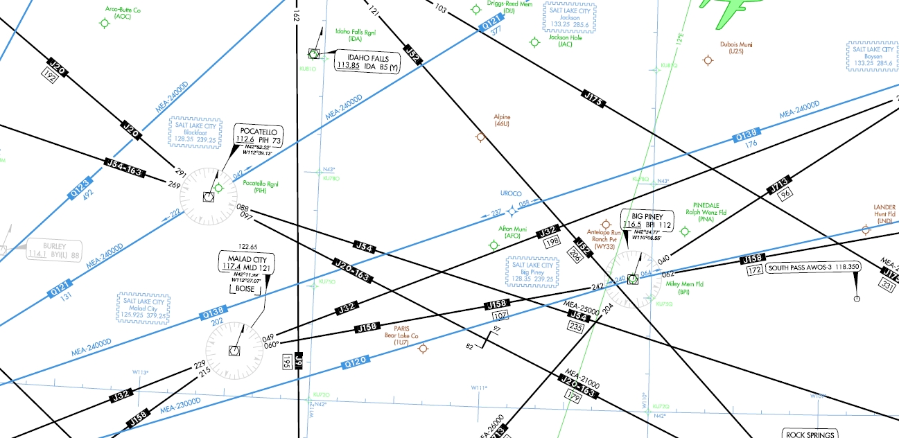
The RNAV concept consists thus into flying routes which are not defined by ground-bases radionav aids like VORs, DMEs, etc. but routes defined by waypoints determined by their GPS coordinates instead. That, on a other hand, necessitates that the plane used be featured with the appropriate receivers, mostly DME/DME, inertials and GPS ones. The RNAV concept allows to a larger use of the enroute airspace. Such RNAV routes have been officialised in the USA by the FAA administration since 2000 as they are figured upon the IFR charts. The 'Q-routes' are used between 18,000 ft MSL and FL450 included as they are drawn with usual IFR enroute high altitude charts. The 'T-routes' are used between 1,200 above surface and 18,000 ft excluded as they are drawn with usual IFR enroute low altitude charts. check a example of a US enroute high altitude Q route
As far as FSX is concerned, as practically a RNAV flight is making use of a GPS, one may consider that the simulator is RNAV compatible. FSX however does not features modern receivers allowing to enter the RNAV route waypoints, or 'track-line computer' (TLC) through entering the radial and distance to a reference radionav aid. In terms of the Q and T RNAV routes, except when included into FMC data updates like that of Navigraph, they are not included with FSX databases. No other choice than to refer to the real world chart and to draw the routes within the Flight Organizer. Virtual airlines, like VATSIM or IVAO, look like they don't use such routes much
In terms of approach, let's point first to that RNAV approaches are non-precision approaches as they do not provide for a glide slope at the difference of precision approaches like ILS ones, for example. Using a RNAV approach, a pilot will have to stepdown along the approach according to charts data. Civil aviation administrations worldwide -and in the USA mostly- first favored the 'GPS approaches' which concerned small planes as they either just stacked those upon existing approaches, either created standalone ones. Then, as the RNAV systems developed, administrations's stacking concerned RNAV approaches upon existing ones, consisting into specific waypoints and headings. Both the GPS and RNAV approaches are currently converging. Some approaches further, in the context of the WAAS concept, are featuring a glide slope. Outside the USA, countries are using the term GNSS instead of GPS
As far as FSX is concerned, its approaches database is dating back to 2005 as it already features GPS overlay, GPS, and RNAV approaches (no GNSS ones). The FSX scenery creation ADE freeware allow to create of modify approaches of which GPS and RNAV ones as systems like the Navigraph FMC is allowing to update their data as they need a payment. Virtual airlines like VATSIM or IVAO are making use of RNAV approaches
Website Manager: G. Guichard, site Lessons In Microsoft Flight Simulator / Leçons de vol pour les Flight Simulator de Microsoft, http://flightlessons.6te.net.htm. Page Editor: G. Guichard. last edited: 6/17/2016. contact us at ggwebsites@outlook.com