 .home page .back Tutorials. GA Planes
The mid-northern latitudes, which are located between the tropical zones and the poles, are featuring weather zones which exist permanently, or which form, with homogeneous characteristics. Those are the anticylones and the cyclones. The homogeneity of such zones is due to that they are existing, or forming, above vast expenses of land, or oceans. The weather, in these regions, thus is determined by a flux of wet, warm air masses, coming from the oceans, as they are regulated, along the year, through the play of powerful anticyclones, which are located more South, or East, or North. For Europe, this way, the cyclones coming from Iceland are permanently flowing towards Europe. During summer, that regularity is interrupted by the fact that the anticyclone of the Azores is increasing and is 'pushing' forwards North. During winter, the flux of the Icelandic cyclone may be modified due to the anticyclone of Siberia! As the latter is gaining West, it may do that rain turns into snow. The same mechanics is found too for North America, with the flux of warm air masses coming from the cyclone of the Aleutians, the regulating air mass in the one of the anticyclone of Hawaii, and the possibly modifying, winter air mass being the anticyclone which forms then over the North of the continent
With depressions passing overs the European, or North American continents, this, most of the time (except during summer when the rainy front let room to a stable-tending, anticyclonic regime, or during winter, when, episodically, the winter anticyclones are yielding snowy and cold weather) gives those regions what one may call a regime of fronts. Long longitudinal bands of clouds, centered on Iceland or the Aleutians are succeding themselves, one after the other, over Europe or North America. Each band -which, so, is a longitudinal, wet, relatively warm, mass of air- is spaced from the following by a dryer -and colder- mass of air. The zone of contact between a warm zone, and a cold one, is called a 'front'. The most current types of front in Europe or North America are the warm, and the cold ones. A warm front occurs when a wet, cyclonic air mass comes to contact to a dry air mass. A cold front, at the contrary, occurs when a dry air mass comes to the contact of one of the longituinal mass of wet air. Such an alternance is of importance to the aviators in Europe and North America because each of those types of weather front is yielding typical meteorological conditions, which, in turn, are impacting any flight performed there, be those in VFR, or IFR conditions
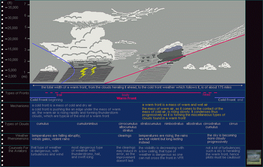 | click on the picture to a view of the weather fronts at the mid-northern latitudes |
The diagram below is showing an explicative sketch of how the warm, and the cold, weather fronts, are alternating between themselves. One finds back thus the characteristic weather to be found for the mid-northern latitudes of Europe, or North America, with a cyclonic front arriving to the contact of a dry, cold air mass, which is preceding it. The warm air, from that, just is rising, slowly, regularly, upwards. As it's rising, the warm, wet air, obviously, is condensating, thus turning into clouds. The slope gradient being moderate, the well-known series of types of clouds, from the most elevated to the lowest ones, forms. The clouds which are the most in altitude, and the immediately following in the series, are heralding the depression, as the clouds coming to be lower -and, eventually, the lowest- 'are' the depression themselves, yielding precipitations! The temperatures are rising. The middle of the cyclonic front is marked by a pause -of a few duration- of the rain. The duration is few, because the dry, and cold air mass which follows soon comes behind, pushing in a edge below the warm and wet, cyclonic air mass. But, this time, the push makes that the warm air is more violently pushed upwards, rising rapidly! Cumulus, rapidly forming, turn swiftly into cumulonimbus, those strong thunderstorm clouds which may rise to towering heights, unleashing their storms! The thunderbolts, inside the clouds, are generated through the motions and frictions which occur, along such a height, between the varied particles to be found inside the clouds, like, for example, hail, raindrops, ice or even dust grains. The cold air proper than just eventually settles after that phase as it's bringing cumulus which are bearing strong rains. Strong wind gales are occurring and the temperatures are abruptly decreasing. When the dry air ban eventually is established, a fine weather is back, with possible cumulus. Then, a new longitudinal, cyclonic mass of air arrives again, with the cycle taking back
In terms of aviation, that form of regularity of the weather conditions over the mid-northern latitudes of Europe and North America, is allowing to the pilots to better understands the kinds of weather to which they may be confronted, or to even forecast the weather changes to come. High in the sky, thus cirrus, and then cirrostratus, are generally heralding a cyclonic front. Any pilot will know, this way, that if he keeps flying a predominantly western heading, it won't take long until he meets a weather front! He will have his route -at least if he is flying VFR- blocked by the front, with the rain and a vanished visibility. The central area of the warm front further, has its precipitations falling down upon the cold air, which is still found below, and saturating it, is generating conditions favourable to fog and haze, those other dreadful conditions any pilot fears. Should clearings appear among the depression, after the rain, the pilots should not be fooled as he better should wait for the rapidly coming end of the front, accompanied with strong thunderstorms if any or, at least, with the coming of the cold front -and its strong turbulences and gales. This being true both for the VFR and IFR conditions! The strong thunderstorms which marks the end of a warm front should, obviously, be an object of worry for the aviators, both VFR and IFR too, as such weather conditions are powerful and dangerous, with their hail, thunderbolts or icing conditions! Any pilot will just have to fly around those zones of thunderstorms. Once the beginning of a cold front over, the aviators may wait for much favourable flight weather conditions, as a fine weather, few wind and an excellent visibility are to occur
Let's have some words about what is called the 'dew point' in terms of aviation weather. That concept is in relation to the question of what quantity of relative humidity is contained in the air. One calls relative humidity of the air -which is expressed in percentage- the relation between the amount of water vapor actually contained in the air and the amount which could be present function of temperature (with warm air generally able to hold more water vapor than cold air). When reaching 100 percent of relative humidity, air is said 'saturated.' Dew point is the temperature at which the air must be refreshed to turn into saturated air. When preparing a flight, pilots must bear a peculiar attention to that value as given by the weather bulletins and forecast. The less the difference between the air temperature and the dew point is, the more there is a risk that clouds and/or fog form. A difference under 2.8° C thus is hinting to a strong probability of fog, clouds or precipitations. As far as fog is concerned, it is of concern to pilots as it is reducing visibility in great proportions, especially in terms of taking off or landing. The fog, on the other hand, may form wery quickly. VFR pilots further have the obligation of always keeping eye-contact with the ground, which the fog may prevent. Fog forms when the air temperature is decreased down to dew point, or when some air close to surface get humidified. Due to the miscellaneous weather conditions which can lead to fog formation, pilots always must worry, especially during seasons or at areas prone to fog, about that potentiality when using the weather bulletins and forecast to prepare a flight. In case when fog should appear once airborne, you would have no other possibility than to divert to a terrain other than the one you wanted to land at
An 'occlusive front' and a 'stationary front' are varieties of weather conditions which occur along the separation line between a mass of warm and wet air, and a mass of cold and dry air. They are occurring function of varied weather specificities. An occlusive front, on a short span of time, is mixing the characteristics of the warm, and of the cold front because both air masses are sliding along each other, bringing to that the warm air mass -which is always followed by the cold one- is eventually trapped between two masses of cold air. A stationary front occur when the weather flux are making that a warm mass of air and a cold one are meeting together, albeit neither is replacing the other. Winds then tend to blow, too, along the line of separation. The weather conditions of a stationary front are a mix of the characteristics of a warm, and of a cold front
Thunderstorms are a other weather event dangerous to aviation due to the varied, strong weather conditions they are generating like hail, winds, etc. Thunderstorms form inside typical cumulonimbus clouds. Thunderstorms can exist isolated or to join other cumulonimbus. A thunderstorm is yielded when wet air is risen aloft by ascendant currents in a cumulative way. Miscellaneous suspended particles in the cloud, like raindrops or ice, etc. are rubbed against each other, producing static electricity which is to be released under the form of lightnings. The base of a cumulonimbus is variable in terms of altitude as they can reach very elevated heights, in a average of 26,500 to 46,500 ft! The best attitude a pilot can hold when encountering a thunderstorm or a stormy area is just to avoid those either that they will not prepare a flight across a area where storms are forecasted or that they will fly around the area concerned, or re-route in case the flight would come to such a area. Beware that a thunderstorm weather events may affect a 32NM-wide area. Thunderstorms hazards are caused by the heavy winds, turbulences, icing conditions, hail and lightnings. As far as lightnings are concerned, they can disrupt instruments or temporarily blind a pilot. Hazards linked to a thunderstrom also exists when a thunderstrom dissipates, that phase being characterized by strong descending currents
Those fundamental weather characteristics which a warm, or a cold front, are featuring, are to be found too in the southern hemisphere. Conditions there are different however due that that hemisphere is featuring fewer landmasses and more water ones than in the northern hemisphere. Australia only allows for the existence of an anticyclone during winter, as the Atlantic, Indian and Pacific oceans, respectively, are giving birth to the anticyclones of the southern Atlantic (or of the St. Helena island), the Mascarene Islands, and the Easter Island. Antarctica, on the other hand, is completely covered with a cyclonic area. It's those zones, like in the northern hemisphere, which are triggering the main weather flux -with the difference that North, the flux are moving eastwards, are they are westwards South. The southern hemisphere, further, doesn't have any monsoon
The other large climatic zones of the world are generating weather conditions of their own, too
At last, as far as the hurricanes, or typhoons, are concerned, those are phenomenons of the same nature. Technically, hurricanes and typhoons are strong depressions in the northern hemisphere. They are generated over the ocean, at the level of the tropics (in the Atlantic Ocean for the hurricanes, in the Pacific Ocean for the typhoons), through the evaporation from the warm waters. Those strong cyclones, then, are taking a western-northwestern path and come to hit, then the Caribbeans, the Gulf of Mexico, or the southeastern U.S.A., for the Atlantic, and the whole area situated from northeastern Indochina to Japan, for the Pacific. Some hurricanes form over the eastern Pacific Ocean as they then are reaching the western coasts of Central America. The hurricane season, over the Atlantic, is from June to October included
Website Manager: G. Guichard, site Lessons In Microsoft Flight Simulator / Leçons de vol pour les Flight Simulator de Microsoft, http://flightlessons.6te.net.htm. Page Editor: G. Guichard. last edited: 5/27/2013. contact us at ggwebsites@outlook.com